
Why does my project require an archaeological survey?
Development projects in the United States are subject to various local, state, and national regulations concerning the conservation of cultural heritage. Legislation such as the 1966 National Historic Preservation Act (NHPA) requires federal agencies to consider the effects of their undertakings on cultural resources, including prehistoric and historic archaeological sites. Agencies at many levels of government have adopted similar laws and regulations.
Why is an archaeological survey important?
Cultural resources are finite and hold the most valuable information when in situ – that is, when they haven’t yet been disturbed by modern activity. Once an archaeological site is destroyed by development, it, and everything it can tell us about how people lived and utilized their landscape, is gone forever. That is why archaeology meticulously records every detail about a site during excavation, so that it’s contents may be preserved for all stakeholders associated with it. Archaeological surveys, however, are about more than just understanding the past. Cultural heritage is a vital part to the health, resilience and identity of communities connected with these archaeological sites and resources.
What is an archaeological predetermination?
An archaeological predetermination is a brief survey that is specific to Clark County, WA, that is designed to determine the presence or absence of cultural resources in the project area. The predetermination establishes whether an archaeological site is present, whether that site will be impacted by the proposed activity, and whether further study is needed.
“Archaeological predetermination” means a preliminary archaeological investigation of a project area which includes, but is not limited to, a review of archaeological databases, walking the site in a series of transects, and the use of shovel test probes of the subsurface as necessary. When archaeological deposits are identified, sufficient shovel test probe examination shall be conducted to determine whether the discovery meets the definition of an archaeological site.
When is a predetermination required?
An archaeological predetermination is required in Clark County for any development application that is subject to State Environmental Protection Act (SEPA) review for a project located either A) within a 20%-100% probability area as defined on the Clark County Archaeological Predictive Model Map, B) within 1,320 feet of a registered archaeological site, or C) within 500 feet of a known but unregistered archaeological site.
- Low potential impacts: Those activities involving no ground disturbance, normal maintenance and repair of existing structures and facilities, lands that have been substantially disturbed to a depth of more than eight (8) inches, and areas that have been adequately surveyed in the past with no discovery of resources.
- Moderate potential impacts: Activities involving slight ground disturbance not otherwise characterized as having low or high impact potential.
- High potential impacts: Activities involving disturbance of more than twelve (12) inches below the ground surface and more than ten thousand (10,000) square feet of area.
Regardless of the probability map designation in Table 40.570.080-1, predeterminations shall be required as specified below:
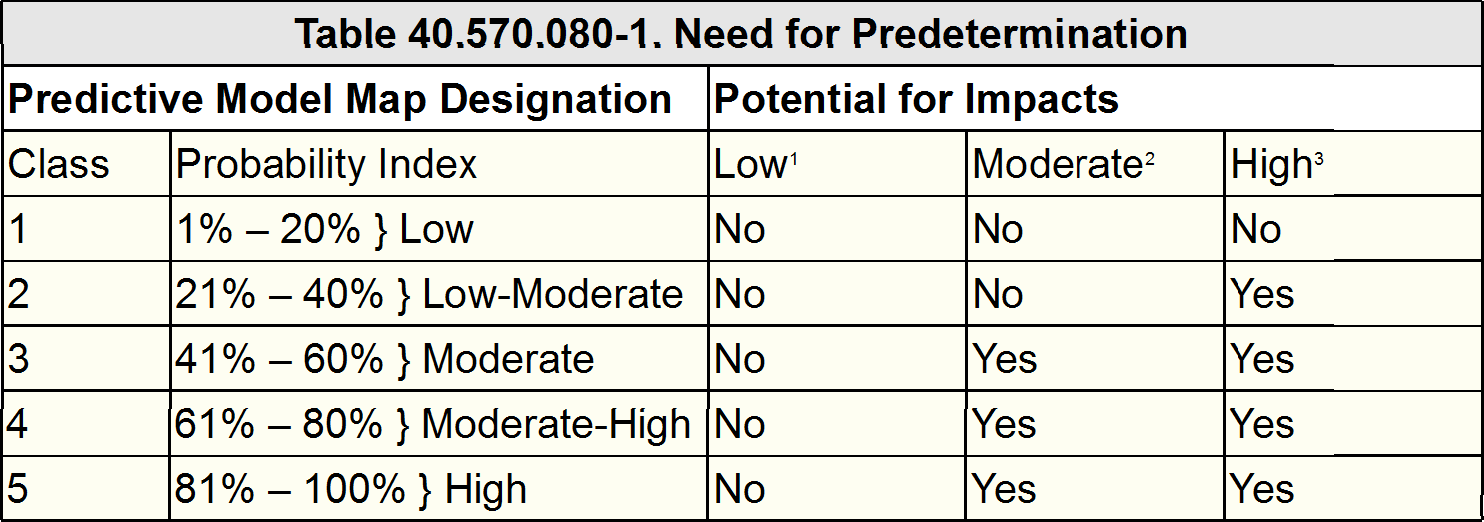
(i) A predetermination shall be required for any high potential impact project located within one-quarter (1/4) mile of a recorded site.
(ii) A predetermination shall be required for any moderate through high potential impact project located within five hundred (500) feet of a known, but unregistered, site.
Who can perform an archaeological survey?
In Washington State, all archaeological work must be carried out by a professional archaeologist who meets the criteria set by the U.S. Department of the Interior. This means that the archaeologist must have a Master’s degree and significant experience in both the field and the laboratory. In many other states, such as Oregon, certain work can be carried out by an archaeologist who lacks a graduate degree but does have significant training and experience. Exceeding the standards of the U.S. Department of the Interior, ASCC is qualified for professional archaeological work in all fifty states.
How will archaeologists conduct the survey?
The exact survey methodology on any given project will vary depending on the terrain, the scope of the project, the specific regulations affecting the project, and the area’s proximity to any known sites. For a typical predetermination, ASCC carries out both a surface and a subsurface investigation. Archaeologists begin by walking the entire project area to assess landforms, to look for archaeological materials, and to determine the best locations for subsurface testing. We then carry out the subsurface investigation by excavating shovel test probes (STPs), cylindrical holes roughly 50 cm (20 inches) in diameter and deep enough to reach subsoil known to predate human occupation. We screen the excavated soils for any artifacts and study the exposed stratigraphy before backfilling. On a more comprehensive survey, such as a Section 106 project, ASCC performs a more rigorous subsurface investigation and also conducts additional background research, using archival maps and literature along with previous technical reports to provide historical context.
What do archaeologists look for?
Archaeologists look for artifacts (which are portable) and features (which are not) left behind by either prehistoric or historical human activity. Prehistoric artifacts commonly include stone tools and the waste flakes made during their manufacture. Historical artifacts can include any diagnostic item datable to more than 50 years old. Features include hearths, shell middens, foundations, pit houses, post holes, and other in situ signs of human occupation.
What happens if archaeological materials are found? Will my project be derailed?
The identification of archaeological materials within a project’s area does not necessarily mean that the project will be halted. Projects may still be completed with little to no modification in the majority of cases where artifacts have been identified. Additional study, however, is generally required when archaeological resources are identified within a project’s area before the project is permitted to proceed. ASCC coordinates with the client and relevant state, federal, and/or tribal agencies to design a mitigation plan appropriate to the project, the archaeological resources, and the client’s goals. In some cases, an avoidance plan will be implemented to ensure that the site goes undisturbed. In other cases, the archaeological finds can be inventoried and evaluated so that the project can proceed as originally planned. Whatever the mitigation strategy, ASCC troubleshoots the process and keeps the plan clear to both the client and the overseeing governmental agencies. A solid working relationship with these agencies helps ASCC to find workable solutions for our clients.
What is a Section 106 survey?
Section 106 of the National Historic Protection Act (NHPA) requires federal agencies to take into account the effects of their actions on significant historic properties. This means that any project funded in whole or in part by federal dollars must undergo a review process to evaluate its impact on any sites, districts, buildings, structures, and objects that are listed on (or eligible for listing on) the National Register of Historic Places. The Section 106 review process is one of consultation with the State Historic Preservation Office (called the Department of Archaeology and Historic Preservation in Washington State) along with interested parties such as developers, local government, and American Indian tribes. As part of this process, archaeological investigation is used to determine what, if any, significant sites and properties could be affected by the proposed project.
What is an EO-21-02 Survey?
Executive Order-21-02 (formerly Executive Order 0505) requires that Washington State agencies with capital improvement projects involve the Department of Archaeology and Historic Preservation (DAHP), the Governor’s Office of Indian Affairs (GOIA), and any interested American Indian tribes into their capital planning process. An archaeological survey is frequently mandated during this process to determine the project’s potential effects on historically significant sites and properties.
What is the National Register of Historic Places?
Maintained by the U.S. National Park Service, the National Register of Historic Places (NRHP) is the country’s official listing of historically significant sites and properties. Registered sites receive limited federal protection and are eligible for financial incentives to encourage their preservation. Although the NRHP itself places no legal obligations on private owners, many states and localities have laws in place to protect their NRHP-listed properties.
What is the State Historic Property Inventory?
The State Historic Property Inventory (not to be confused with the National Register of Historic Places) is a listing of historic buildings, structures, sites, districts, and objects throughout the state. Maintained by each state’s historic preservation office, the Historic Property Inventory is used for planning and research purposes. If a historical property is present in the project area, the state can require that a Historic Property Inventory Form is filled out before the project is permitted to proceed. Adding a property to the Historic Property Inventory does not prevent it from being altered or demolished by its owner.
"Have you found any gold/dinosaurs?"
Nope! What may be the most common questions asked of archaeologists by curious members of the public is actually a gross misconception of archaeology’s aims. Despite the appearance of wide-brimmed hats and sifting trays, archaeologists have no interest in either gold deposits or dinosaur bones. Those pursuits are limited to the goals of prospectors and paleontologists. Archaeology is, however, interested in the record of human use and habitation of the studied landscape.